
Unbiased headlines. Facts, not spin.
Unbiased Headlines is an independently owned news organization. We bring you the facts, not opinions, written fresh from 110+ named sources. Sources linked so you can verify it yourself.
 economy
Notable (6/10)
economy
Notable (6/10)
NOAA Winter Outlook Favors Warmer Weather in 41 States as Strong El Niño Pushes Storms South
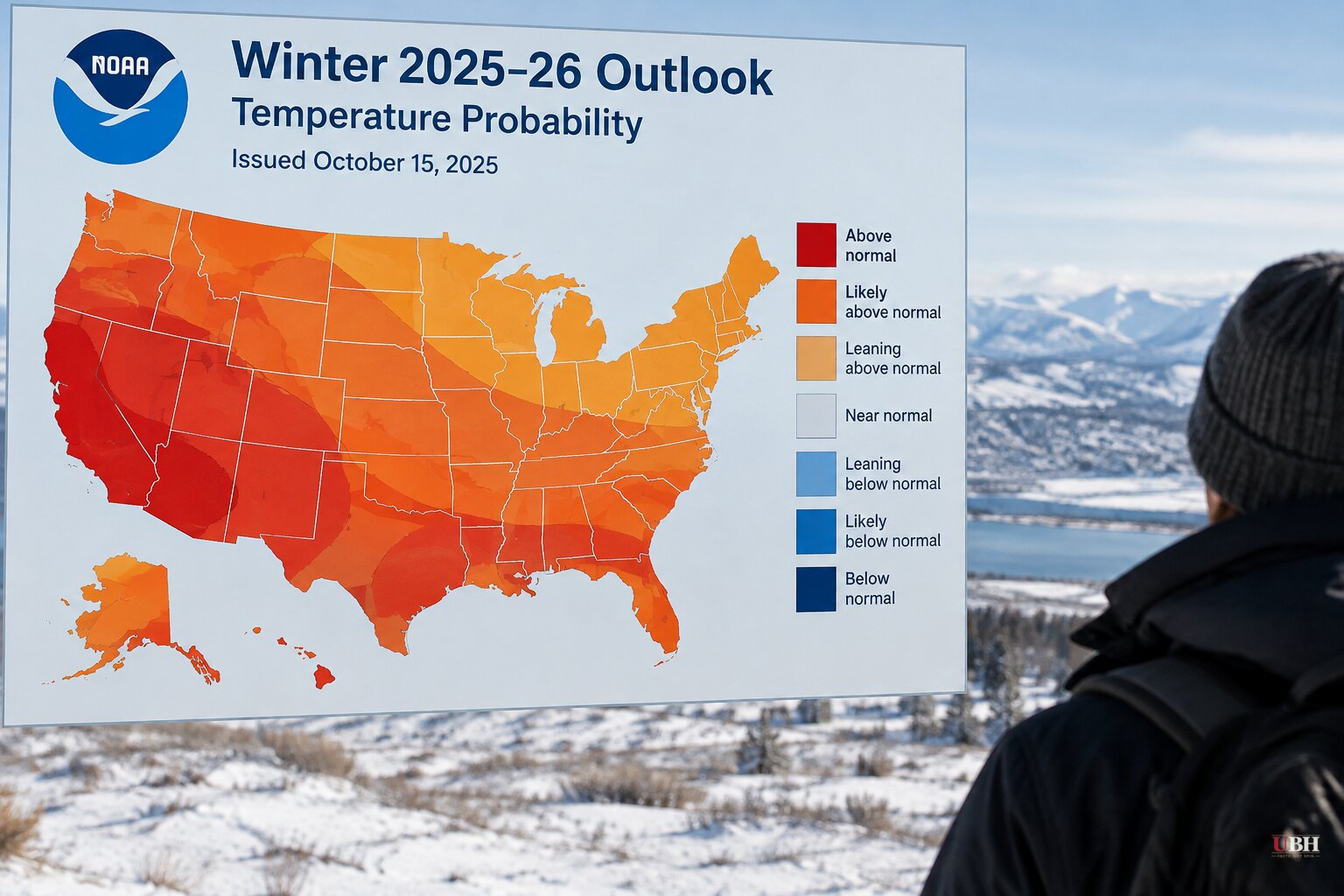
Since the 2023-24 El Niño faded, forecasters have been tracking the next one. Today, Oct. 15, NOAA's Climate Prediction Center put out its official winter outlook, and the new El Niño dominates it.
The outlook covers meteorological winter, Dec. 1 through Feb. 28, 2027. NOAA describes the current El Niño as near-record strong. It is expected to peak in December and could last into March 2027.
Warm almost everywhere
Part or all of 41 of the Lower 48 states are forecast to be warmer than normal. No state, or even part of a state, is forecast to run cooler than average.
Florida, Louisiana, southern Georgia, Alabama and Mississippi are forecast near normal. Texas, New Mexico, Arizona, Utah, Southern California, Nevada, Wyoming, western Oklahoma, Kansas and Nebraska have equal chances of warm, cold or normal.
The Upper Mississippi Valley is favored for warmer-than-normal weather at 40 to 60 percent probability. The NWS office in La Crosse, Wisconsin, noted that in its records since 1949-50, 5 of 9 strong or very strong El Niño winters there landed among the warmest third of all winters. In Rochester, Minnesota, it was 6 of 9.
Those are odds, not guarantees. NWS Director Ken Graham said a very strong El Niño "will likely bring a southward and eastward shift to the jet stream for the contiguous U.S., which tilts the odds toward stormier weather across the South."
Wetter South, thirstier West gets relief
The shifted jet stream is expected to bring above-average precipitation to the West Coast and the southern states. NOAA said that could help erase the persistent drought in the West. Precipitation along the Eastern Seaboard is also forecast above average.
Warmer ocean water and warmer air carry more moisture, so any storm that strikes could dump heavier rain or mountain snow. Across the Southeast and parts of the southern Plains, the cooler, wetter pattern sets up the possibility of snow, sleet and freezing rain. How much falls depends on whether cold air lines up with storms.
NOAA meteorologist Jon Gottschalck said some southern-tier storms may turn northeast along the East Coast. That could bring heavy rain and snow to Mid-Atlantic and Northeast cities, depending on cold air. "These storms could be very strong," he said.
Less snow up north
The weather service does not issue seasonal snowfall forecasts. Its meteorologists said much of the northern U.S., including the Northeast, Great Lakes, Upper Midwest and Northern Rockies, should expect below-normal snow. The Southern Rockies and parts of the Southeast and Southwest may get more than usual.
Private forecasters agree. AccuWeather expects Chicago, Boston, New York and Philadelphia to get about half or less of their normal winter snow. Salt Lake City is the only big metro it expects to beat normal.
"This is going to be a winter that's really difficult for them to find what they're looking for," said James Belanger, vice president of meteorology for the Weather Company. His advice for a white Christmas: fly to the Southern Rockies.
The weather service also expects a stronger jet stream to keep most polar air, the source of polar vortex outbreaks, to a minimum.
Chicago: milder, but not snow-free
For the Chicago area, the weather service puts the chance of above-normal temperatures at 50 to 60 percent. Precipitation is a toss-up. The Climate Prediction Center sees roughly equal chances of above or below normal in the Midwest.
The weather service says the current El Niño is expected to compete with 1982-83 for the strongest since 1950. That winter raised average temperatures in the Chicago area by five to seven degrees and cut snowfall by 25 to 50 percent.
"It's not a guarantee, but given this one is overly strong, confidence is pretty high," said Kevin Doom, a weather service meteorologist. He added that the winter will probably feel like any other warm one, especially in the second half, but "we'll still see periods of harsh cold and wintry precipitation events."
Chicago typically gets about seven inches of snow in December and about 11 inches in each of January and February. One or two big storms could swing a season total well away from a below-normal forecast.
What the forecast does not erase
Forecasters stress that no two El Niños are alike. The weather service's own report says "no two El Niños are alike and impacts vary."
Graham put it plainly at the media briefing: "Even in the winter months, it doesn't mean you're not going to have snow. It doesn't mean you might not have a snowstorm. So it doesn't erase the risk."
NOAA also noted that the U.S. winter has warmed about 4°F (2.2°C) over the past 50 years, which it attributes predominantly to human-caused climate change. That is a long-term trend layered on top of this season's El Niño, which is a natural, temporary warming of the Pacific.
The East Coast is the open question. Gottschalck's warning about strong storms turning up the coast depends on cold air being in place when they arrive. That will not be clear until the pattern develops after El Niño peaks in December.
The Climate Prediction Center's next seasonal update will show whether the odds tilt further.
Sources used for this briefing
8 links from 8 independent newsrooms (syndicated copies of the same report count once)
These are the sources it draws on, linked so you can verify.


