
Unbiased headlines. Facts, not spin.
Every story is an unbiased news briefing written from 110+ sources across the spectrum — sources linked so you can verify it yourself.
 energy
Notable (6/10)
July 28, 2026 at 03:24 PM
energy
Notable (6/10)
July 28, 2026 at 03:24 PM
France's First Confirmed Fire-Generated Thunderstorm Has Stopped Spreading, Officials Say
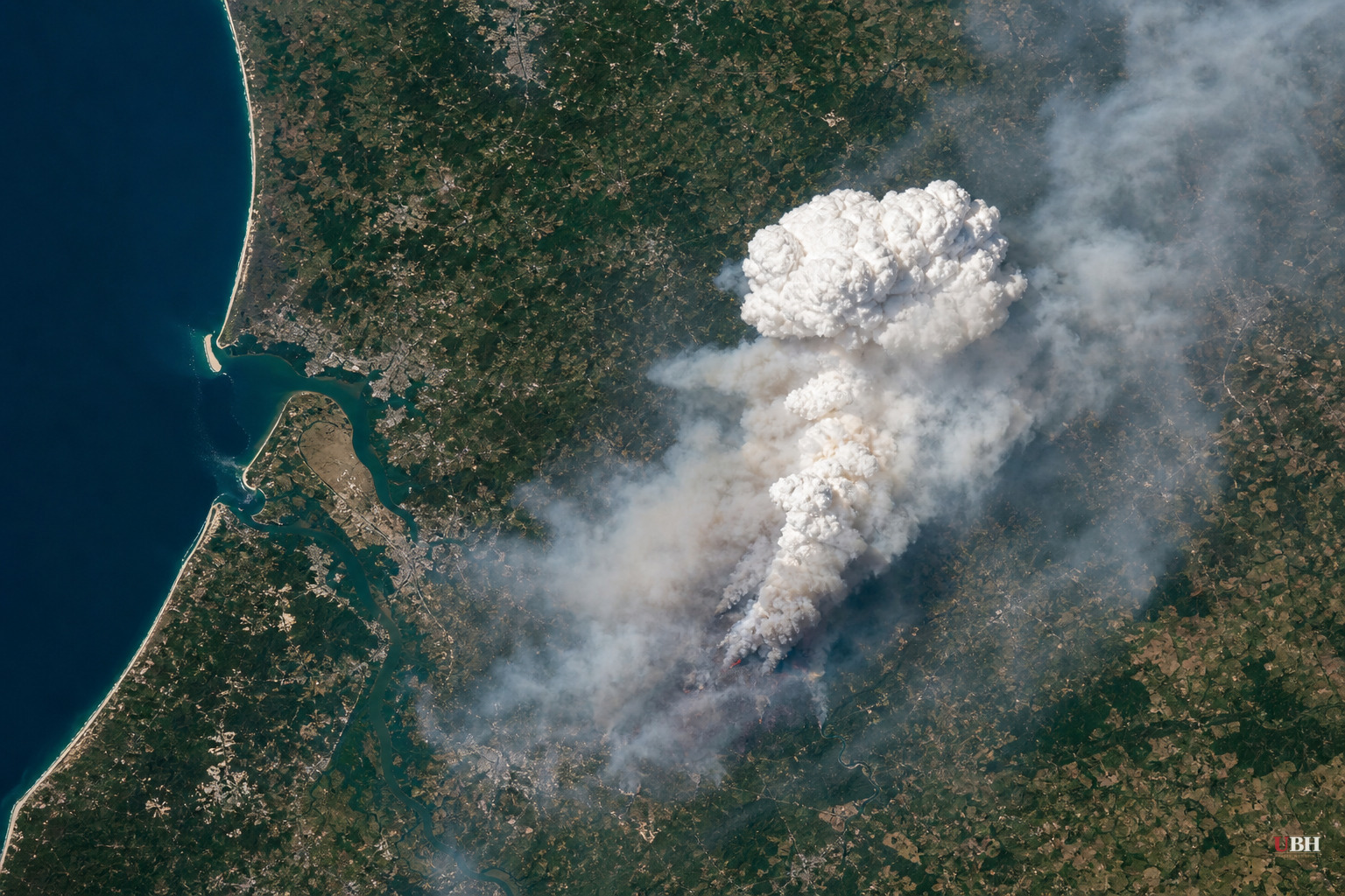
Fire Stopped Growing, But the Damage Is Done
Since French officials confirmed the country's first-ever pyrocumulonimbus cloud over the Gironde wildfire on July 25, the fire has stopped expanding, according to French authorities cited by PBS. The fire itself started near Saumos on July 22. It burned more than 420 square kilometers, roughly 162 square miles, destroyed or damaged over 240 homes, and forced about 220,000 to 250,000 people to evacuate depending on the count, with the Independent and Newswav both citing a figure north of 250,000.
The fire cloud, or pyroCb, is what made this blaze something firefighters had never dealt with before on French soil. France's national firefighters federation, the FNSPF, said it had never before recorded one.
What Actually Happened Meteorologically
At about 6:20 p.m. on Friday, July 25, two days after the fire ignited, the departmental fire and rescue service confirmed the fire had generated a pyrocumulonimbus cloud, according to the Associated Press via PBS. The cloud weakened overnight as humidity rose, then reformed multiple times.
Theodore M. Giannaros, a fire meteorologist at the National Observatory of Athens, explained the mechanics plainly: "Imagine a campfire so large and hot that the smoke rising off it turns into a storm-like cloud. That is a pyroCb, a storm cloud born from the intense heat that a wildfire produces."
There's no magic temperature threshold. Giannaros said what's needed is the kind of atmosphere that produces dry thunderstorms: very hot, dry air near the ground with cooler, moister air above it. Hot smoke-loaded air rises fast, cools, and water vapor condenses around ash particles. Above the freezing line, ice crystals collide and separate electrical charges, same as any thunderstorm. The difference is what's underneath: a landscape already on fire.
"It's a feedback loop, not a one-way effect," Giannaros said. "Once it forms, the cloud becomes its own weather system, sitting on top of the fire and making it harder to predict."
Why Firefighters Couldn't Touch It
A spokesperson for the FNSPF, Eric Brocardi, described the situation to local outlets and the New York Post as a "David-versus-Goliath scenario." Unlike a normal wildfire that spreads in a predictable cone, he said, a pyroCb-driven fire spreads in every direction and develops multiple fire fronts simultaneously. "We don't know how the blaze will spread; the fire front is constantly shifting. We cannot fight it directly."
Jean-Baptiste Filippi, a fire researcher at the University of Corsica, told New Scientist: "These cells are unstoppable. You cannot stop a thunderstorm, and neither can you stop a firestorm."
The storm's downdrafts punch gusts back to the surface while updrafts pull in fresh air toward the fire, shifting flame direction with little warning. Dry lightning from the cloud struck ground well beyond the fire's actual perimeter, igniting new spot fires on already-parched terrain, according to the Independent and Newswav.
The Broader Context
Spain separately declared a national emergency after a wildfire burned near Madrid, which regional president Isabel Díaz Ayuso called the worst in the region's history, according to the Independent. That's a parallel crisis, not the same fire, and it underscores that the Gironde blaze wasn't an isolated event this fire season.
President Emmanuel Macron met with his cabinet to discuss the crisis and said Bordeaux itself, roughly 7 to 9 miles from the fire's edge depending on the source, would not be evacuated. That decision held. The city was never abandoned, even as the fire cloud loomed nearby.
Rick McRae, an adjunct professor with the University of New South Wales' bushfire research group, told the Guardian: "It's the first time France has had to explicitly consider the concept of a pyroCb. Whether or not they had one a few days back or not isn't really the question. The question is whether there's one coming."
What Remains Uncertain
French authorities have said the Gironde fire stopped growing, but they have not given a full containment timeline, and the fire's total acreage figures still varied slightly across outlets as of this reporting, from 42,000 hectares (about 162 square miles) cited by the Independent and Newswav to slightly different totals in earlier AP figures. Meteorologists have not yet said whether France's pyroCb will be formally reconfirmed by climate scientists as the country's first officially logged instance, which several outlets noted remains pending formal confirmation. Whether France sees another fire cloud form before the summer ends remains the open question fire researchers are watching.
Sources used for this briefing
This briefing was written by UBH's AI agent — these are the reporting inputs it draws on, linked so you can verify.


