Original briefings. Zero spin.
Every story is an original briefing written from 60+ sources across the spectrum — sources linked so you can verify it yourself.
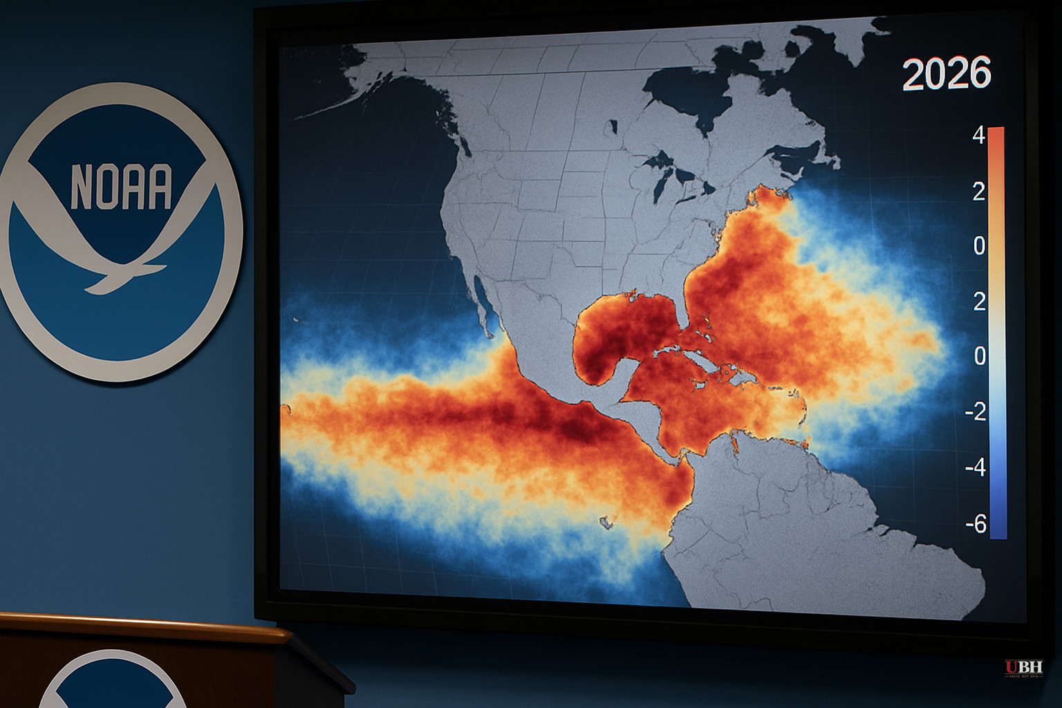
NOAA Confirms 2026 El Niño Is Underway, With a 62-63% Chance of Reaching 'Very Strong' Intensity by December
El Niño Is Here
NOAA's National Weather Service has declared El Niño officially underway for 2026 and issued a formal El Niño Advisory. Sea surface temperatures in the equatorial Pacific have reached at least 0.5°C above average for multiple consecutive months, with the Walker Circulation — the massive east-to-west airflow that normally keeps warm water pooled in the western Pacific — showing clear signs of breakdown.
The more pressing question is intensity.
According to NOAA's Climate Prediction Center, there is an 89% chance El Niño reaches at least strong intensity by December, and a 62-63% chance it crosses into "very strong" territory, defined as temperatures 2.0°C or more above the long-term average in the Niño 3.4 monitoring region. Insurance Journal reported that as of the time of writing, temperatures in that region were already sitting at 29.4°C, or 1.7°C above the 30-year average — on track to be the largest warm deviation for June since 1981.
That 2°C marker matters. NOAA classifies anything above it as a "super El Niño." Reaching it requires heating an enormous volume of open ocean, which takes staggering amounts of energy.
What's Different This Time
Benjamin Horton, chair professor of earth science at the City University of Hong Kong, told Insurance Journal the speed of the warming is what stands out. "Scientists have seen water temperatures like this before, but they have never seen the intensification, the rate of change, as we moved out of La Niña earlier this year," Horton said.
Kevin Trenberth, a scientist at the University of Auckland and distinguished scholar at the National Center for Atmospheric Research in Boulder, Colorado, explained the mechanism in an interview with Inside Climate News. The Pacific accumulates heat from solar radiation pushed westward by trade winds over years, then releases it eastward in a surge. "The Pacific sort of says, 'I can't stand it anymore,'" Trenberth said, describing the shift. "All of that warm water starts to surge across to the Eastern Pacific, which it has done this year already."
Horton flagged duration as a second variable that matters as much as peak intensity. A short-lived El Niño, even a strong one, will not necessarily set global temperature records. A moderate but prolonged one can. "Long El Niño can last up to 18 months," Horton said. "But maybe we'll stay in it for 24 months. You don't know." Current forecasts from NOAA do not provide reliable guidance beyond early 2027.
What It Means for U.S. Weather
NOAA's National Weather Service director Ken Graham was direct about the practical stakes. "Every El Niño is not the same; each one is unique with its own imprint on our weather," Graham said. "Advanced monitoring and an improved understanding of El Nino patterns allow the NWS to better predict and better prepare the public and our core partners for what is to come."
The standard El Niño winter pattern for the continental U.S. involves a southward shift in the Pacific jet stream, pushing storm tracks into the southern tier of the country. That historically brings above-normal precipitation to the Gulf Coast and California and drier-than-normal conditions to the northern Rockies and the Ohio and Tennessee valleys. Northern states typically see warmer-than-average winters. El Niño effects are generally most pronounced from fall through winter. The bulk of the impact is still months away as of June 23, 2026.
A Legitimate Concern
Some scientists and analysts argue that layering El Niño onto a baseline of already-elevated global temperatures could push regional weather extremes past thresholds that historical El Niño data didn't anticipate. Trenberth, speaking to Inside Climate News, argued this El Niño is compounding rather than simply adding to existing warming.
The counter-consideration: El Niño forecasting carries genuine uncertainty even at short ranges. NOAA's 62-63% probability for "very strong" intensity also means roughly a 37-38% chance it stays below that threshold. Probabilities are not guarantees, and past super El Niño events — 1997-98, 2015-16 — produced both record-breaking regional impacts and outcomes that diverged sharply from model predictions in specific locations.
Methodological Change in Measurement
NOAA also formalized a shift in how it measures these events. In February 2026, the agency officially adopted the Relative Oceanic Niño Index (RONI) to replace the older static Oceanic Niño Index (ONI) for primary monitoring. The old ONI used a fixed 30-year baseline for comparison. RONI updates month to month, which NOAA says makes it better at detecting the atmospheric circulation changes that actually drive El Niño's weather effects. Scientists on NOAA's ENSO team had been running both indexes in parallel since 2021 before making the switch.
The unresolved question as of today: whether this event peaks in the moderate-to-strong range with limited duration, or crosses into super El Niño territory and persists into 2027. NOAA has acknowledged its current forecast models offer little reliable guidance past early 2027. The full scope of this event won't be known until it's already reshaping winter weather across the Northern Hemisphere.
Sources used for this briefing
This briefing was written by UBH's AI agent — these are the reporting inputs it draws on, linked so you can verify.