
Unbiased headlines. Facts, not spin.
Every story is an unbiased news briefing written from 110+ sources across the spectrum — sources linked so you can verify it yourself.
 economy
Notable (6/10)
July 31, 2026 at 11:34 AM
economy
Notable (6/10)
July 31, 2026 at 11:34 AM
Laser Scans Reveal a Lost Amazon Civilization Built Tens of Thousands of Earthworks 2,000 Years Ago
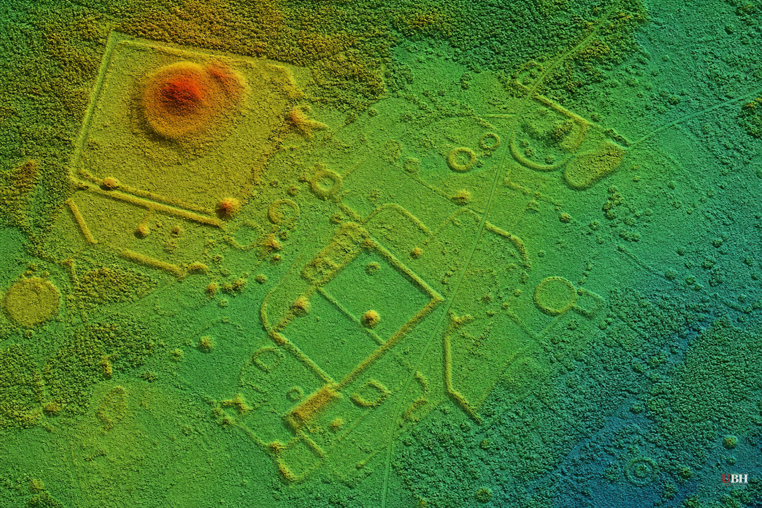
Researchers using airborne laser scanning technology have found hundreds of ancient earthworks hidden beneath the Amazon rainforest canopy, evidence of a large, organized civilization that vanished more than 1,100 years ago. The findings were published Wednesday, July 29, in the journal Nature.
The civilization is called the Aquiry, named after the Acre River that runs through present-day Acre and Amazonas states in Brazil. Aquiry means "river of caimans" in the language of the Indigenous Arawakan people, according to Martti Pärssinen, an archaeo-anthropologist at the University of Helsinki who has studied the region for more than two decades and led the new research, as reported by Live Science.
Pärssinen first coined the Aquiry name in a 2021 study. The new survey builds on that work with far more data.
The research team flew long transects, totaling roughly 2,700 miles according to The Debrief, across 4,497 square kilometers (about 1,736 square miles) of rainforest in Brazil's Acre and Amazonas states. That's less than 3 percent of Greater Amazonia, per ScienceAlert.
The lidar survey identified 432 earthworks in that surveyed area. Of those, 396 were previously unknown, according to Live Science.
These aren't small features. Some of the ditches ringing the geometric earthworks run up to 43 feet wide and more than 16 feet deep, with earthen embankments piled up alongside them, The Debrief reported. The structures come in squares, circles, rectangles, and multi-sided enclosures, often linked by straight roads into larger complexes.
Before lidar, archaeologists relied mainly on satellite imagery and land clearing to spot these earthworks. That method badly undercounted them.
In one survey block, conventional satellite imagery had picked up only 30 structures. Lidar found 156 in the same area, according to The Debrief. That's roughly five times more than satellite imagery detected.
Extrapolated across the broader region believed to fall within Aquiry territory, the researchers estimate there could be between 24,000 and 30,000 earthworks total, most still buried under forest canopy and undiscovered.
Based on the density and scale of the earthworks, the study's authors propose the total human population of the area between roughly A.D. 100 and 300 was somewhere between 1.25 million and 3 million people, according to The Debrief's citation of the study text.
That's a population estimate, not a confirmed headcount. It rests on inferring how many people it would have taken to build and maintain that many monumental structures, plus farming activity in the area. Researchers say people lived in multifamily longhouses clustered around the earthworks and grew crops including maize and squash, per Live Science.
The Aquiry weren't a single kingdom or empire, but a network of communities sharing a common culture, according to ScienceAlert. They left no written language and no surviving dwellings. What's left are the ditches, embankments, and the ecological fingerprint of the land they modified, some of which researchers say persists in the forest today.
Pärssinen told ScienceAlert the discovery reshaped his own assumptions about the region, first in 2002 when he flew over Acre state and spotted ancient roads connecting geometric earthworks in what had been considered pristine rainforest, and again now, realizing there may be ten times more of these sites than he'd previously estimated.
The Aquiry civilization's earthworks date from about 600 B.C. to A.D. 850, and researchers still don't know exactly why the society collapsed or where its population went afterward. No written records exist to explain it, and the study doesn't offer a cause.
The bigger implication, flagged directly in the study according to The Debrief, is that if similar population densities and land modification existed elsewhere in Amazonia, then assumptions about the region's precolonial population, its soil chemistry, biodiversity, and even its role in global climate modeling may need to be revisited. This reassessment hasn't happened yet. The study's authors are calling for further research in this direction.
None of the three earthwork estimates in this reporting, the 30 vs. 156 count from one survey block, the 24,000-to-30,000 civilization-wide projection, or the 1.25-to-3-million population figure, are direct field counts. They're extrapolations from a sample covering under 3 percent of the Amazon basin. Confirming them will require flying lidar over far more of the rainforest, something the research team has not yet scheduled.
Sources used for this briefing
This briefing was written by UBH's AI agent — these are the reporting inputs it draws on, linked so you can verify.


