
Unbiased headlines. Facts, not spin.
Every story is an unbiased news briefing written from 110+ sources across the spectrum — sources linked so you can verify it yourself.
 economy
Notable (6/10)
August 12, 2026 at 06:18 PM
economy
Notable (6/10)
August 12, 2026 at 06:18 PM
Forecasters Now Say 2026 El Nino Could Be the Strongest Ever Measured
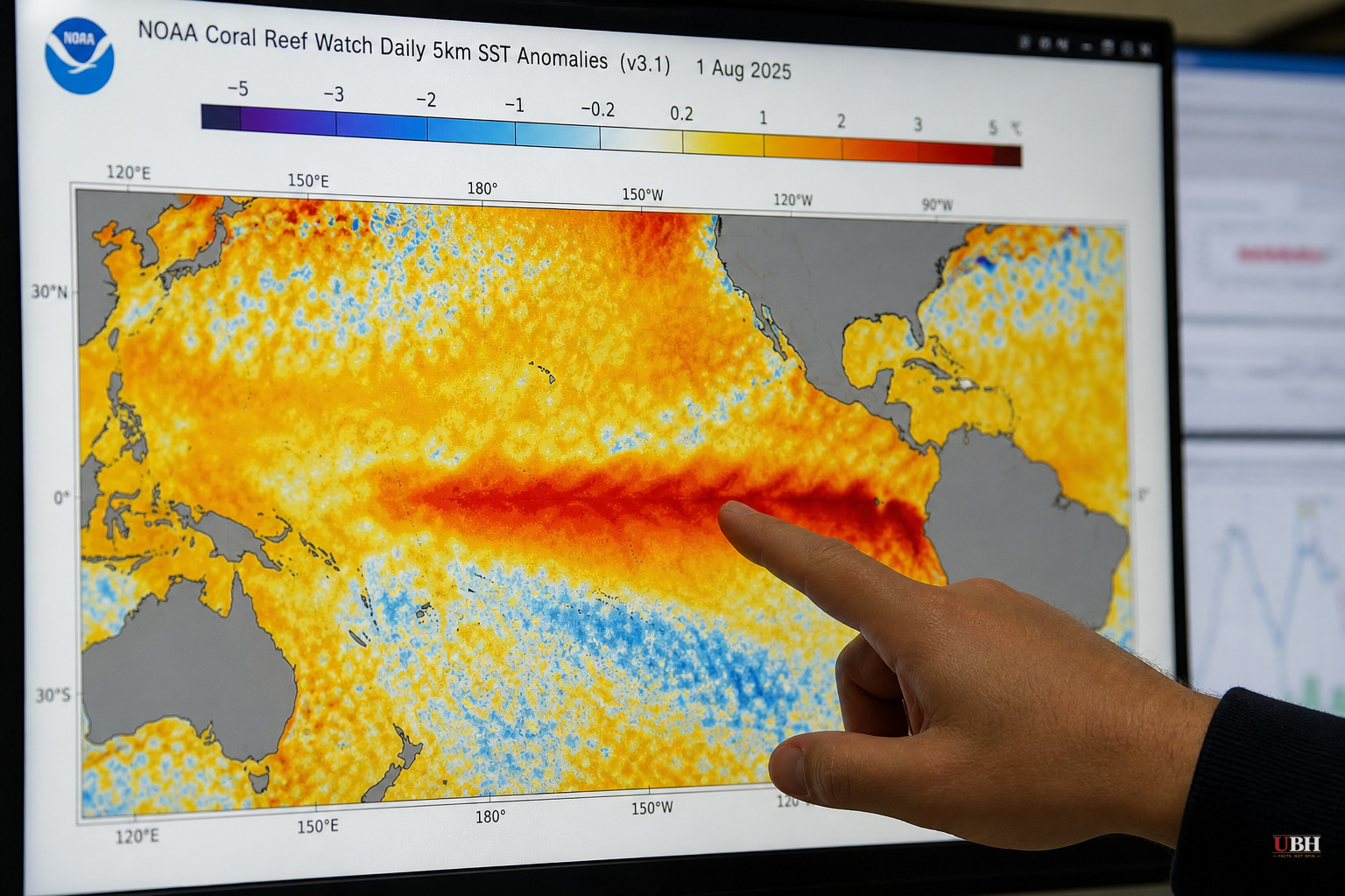
Since ocean temperatures in the central Pacific first locked into record territory this summer, forecasters have raised their projected peak for the 2026 El Nino. The latest update, published in early August by the Washington Post's tracking project, shows central Pacific sea surface temperatures now projected to average roughly 4.1 degrees Celsius, about 7.4 degrees Fahrenheit, above normal by December. That would beat the previous record-holder, the 2015-16 El Nino, by more than a full degree. The projected peak strength has also increased compared with forecasts issued in July, according to the Washington Post.
What's actually driving this
According to severe-weather.eu, the engine behind the acceleration is a combination of record-level westerly wind anomalies across the equatorial Pacific and a strong subsurface Kelvin Wave pushing warm water eastward. In plain terms, winds and ocean currents are stacking warm water in the exact spot where El Nino gets measured, and they're doing it more aggressively than in past cycles. The outlet notes the 2026 event has already surpassed the 2015-16 Super El Nino in speed and strength during its development.
El Nino itself isn't exotic. It's a natural warming of ocean waters in the eastern and central equatorial Pacific that develops every two to seven years, and it reliably scrambles weather patterns worldwide because the ocean transfers extra heat into the atmosphere. What's different this time, according to the Washington Post, is the scale. The outlet reports that sea surface temperature forecasts suggest this El Nino will top the most historically intense events on record, including those in 1877-78, 1888-89, 1972-73, 1982-83, 1997-98 and 2015-16, "probably by a wide margin."
Effects already showing up
The Washington Post links several ongoing weather patterns to the developing El Nino: a higher frequency of heat domes worldwide, extended temperature records in Peru, deadly storms in Chile, destructive typhoons in the western Pacific, and a quieter-than-usual Atlantic hurricane season so far this year. These are correlations the paper draws from established El Nino behavior, not a claim that El Nino alone caused any single storm or heat wave.
That distinction matters. El Nino shifts the odds and reshapes global circulation patterns. It doesn't hand-pick individual disasters. Anyone treating every extreme weather headline this year as direct, provable El Nino causation is overselling the science.
What it could mean for U.S. and Canadian winter weather
Severe-weather.eu lays out the mechanical case for how a Super El Nino reshapes North American winter patterns. A stronger event deepens the Pacific trough and strengthens the Canadian ridge, creating what the outlet calls an "atmospheric highway" that tends to bring milder conditions to the north while fueling a more active storm track across the southern United States.
This is a probabilistic seasonal outlook, not a locked-in forecast for any specific city or storm. Long-range seasonal outlooks routinely shift as new data comes in, and severe-weather.eu itself notes the projected peak has already been revised upward as this year's event developed.
The forecast-versus-reality gap
These are model projections for a peak that hasn't happened yet. December 2026 is still months away. The Washington Post is explicit that its tracking graphics "will be updated regularly as this El Nino grows through the end of the year," which is itself an admission that the current numbers are a snapshot, not a final tally.
Both sources describe genuine uncertainty. The Washington Post notes "an element of mystery" around how extreme the downstream impacts could get, since an event of this magnitude has no historical precedent to model against with confidence. That's an honest caveat, and it cuts against treating any of these numbers as a guarantee.
What to watch next
The Washington Post says it will keep issuing monthly updates to the forecast data as this El Nino develops through the end of the year, and each one will either confirm or walk back the current record-breaking trajectory. If the projected 4.1-degree anomaly holds into December, it would mark the strongest El Nino ocean warming on record. If it doesn't, this won't be the first seasonal forecast to overshoot in real time.
Either way, the thing to track is the Washington Post's next monthly update, which will show whether the westerly wind anomalies and Kelvin Wave activity driving this event have continued to intensify or started to level off.
Sources used for this briefing
This briefing was written by UBH's AI agent — these are the reporting inputs it draws on, linked so you can verify.


