
Unbiased headlines. Facts, not spin.
Unbiased Headlines is an independently owned news organization. We bring you the facts, not opinions, written fresh from 110+ named sources. Sources linked so you can verify it yourself.
 energy
Notable (6/10)
Cyclone Arnab Forecast to Hit Andhra Pradesh Coast Wednesday as 570,000 Are Identified as Vulnerable
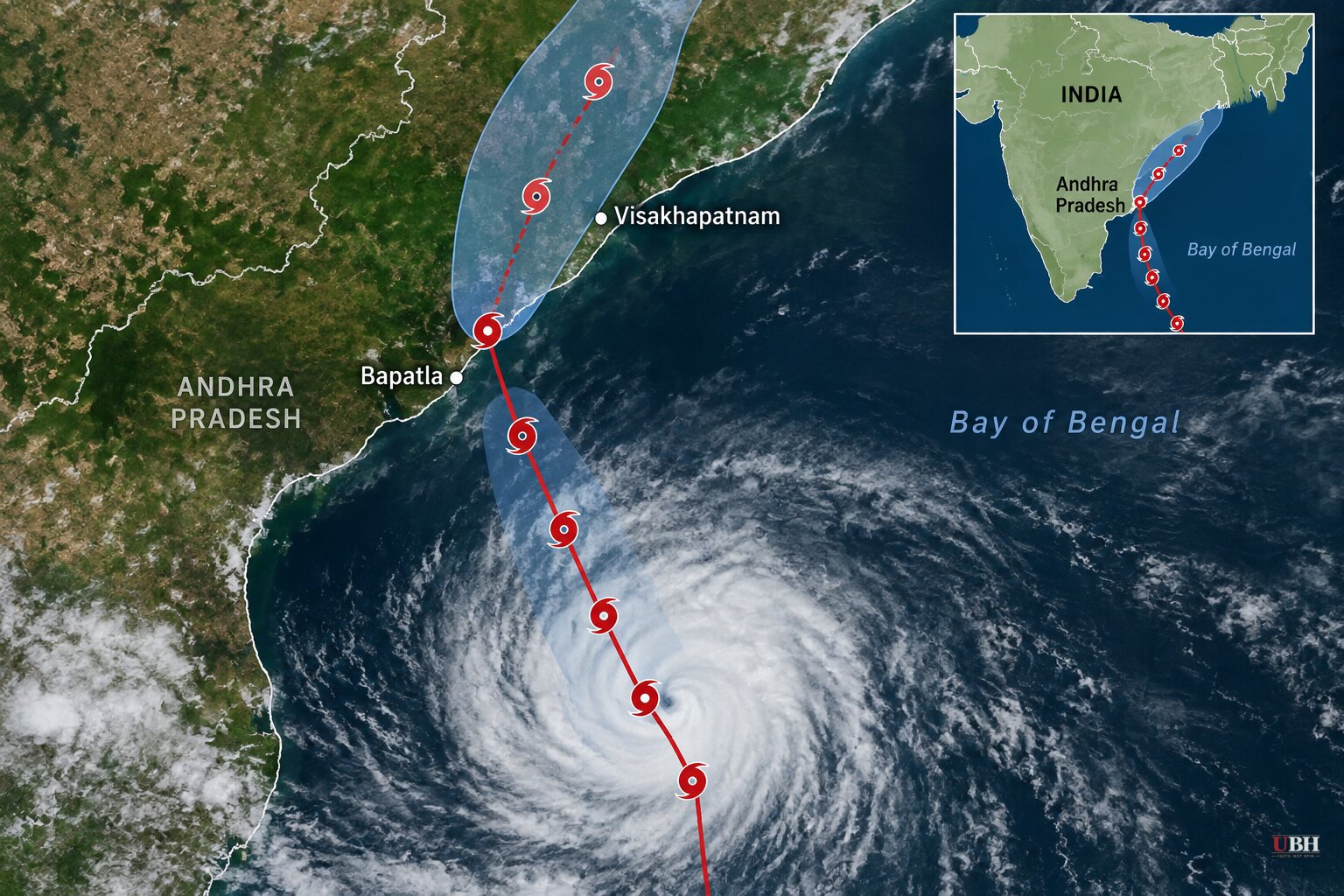
Cyclone Arnab is on course for India's eastern coast, and two states are moving people out of its way.
The India Meteorological Department (IMD) said Monday, Oct. 26, that the system had intensified from a deep depression into a cyclonic storm over the Bay of Bengal. It is moving west-northwest and is forecast to become a very severe cyclonic storm by Tuesday, Oct. 27.
Where and when it is forecast to land
The IMD expects Arnab to cross the Andhra Pradesh and Yanam coasts between Bapatla and Visakhapatnam by the forenoon of Wednesday, Oct. 28. Maximum sustained winds at landfall are forecast at 115 to 125 kmph (roughly 71 to 78 mph), with gusts up to 140 kmph (87 mph).
The storm had been moving at about 13 kmph. Its latest reported position was roughly 540 km from Visakhapatnam, 620 km from Kakinada and 790 km from Bapatla.
The forecast carries uncertainty. Landfall timing, location and intensity can all shift as the system develops, and the damage will depend on its precise track.
Rain across several states
The IMD forecasts isolated extremely heavy rainfall over coastal Andhra Pradesh and Yanam on Oct. 27 and 28. It also expects extremely heavy rain in Odisha on Oct. 28, in Chhattisgarh on Oct. 28 and 29, and in east Uttar Pradesh on Oct. 29.
Districts flagged for heightened monitoring in Andhra Pradesh include Visakhapatnam, Alluri Sitharama Raju, Anakapalli, Kakinada, Konaseema, East Godavari, West Godavari, Eluru, NTR, Krishna and Guntur. In Odisha, the focus is southern districts including Ganjam, Gajapati, Rayagada, Koraput, Malkangiri and Nabarangpur.
Further south, Tamil Nadu and Puducherry are already getting northeast monsoon rain. In the 24 hours ending 6 a.m. Monday, Rameswaram, Pamban, Thangachimadam and R.S. Mangalam in Ramanathapuram district each recorded over 100 mm. Cyclone warning signals have been hoisted at ports including Chennai, Nagapattinam, Cuddalore, Karaikal, Pamban and Thoothukudi. Several Kerala districts are under rain alerts as well.
What the states are doing
A senior Andhra Pradesh disaster management official told Reuters the state has identified 570,000 people as vulnerable. Evacuations were slated to begin Monday evening. That number is the population at risk, not the number moved so far.
The state released ₹27 crore to 20 districts for relief operations and has deployed 15 National Disaster Response Force teams. It has called boats back to shore and ordered fast restoration of power if lines go down. Prakhar Jain, managing director of the Andhra Pradesh State Disaster Management Authority, said the next three days would be crucial and urged residents to take precautions.
The authority has also published emergency numbers for the State Emergency Operations Centre: 112, 1070 and 1800 425 0101.
Odisha has banned fishing and restricted tourist access to hills, waterfalls and dams in vulnerable areas. It is preparing to move residents of low-lying areas into cyclone shelters. Chief Minister Mohan Charan Majhi has assigned eight ministers to monitor preparations.
School closures in Odisha have been described differently from one announcement to the next. Reports cite five or six southern districts, with closures running Tuesday and Wednesday in some accounts and Oct. 28 and 29 in others. Parents should check with their district administration.
The stated goal from both states is "zero loss of life and minimal damage to infrastructure."
Why the name
The name Arnab was proposed by Bangladesh and comes from the list of tropical cyclone names adopted in April 2020. It means "sea" or "ocean" in Bengali.
What comes next
The IMD is due to issue further bulletins as Arnab strengthens. The first checkpoint is whether it reaches very severe status by Tuesday, Oct. 27, as forecast. Those updates will also show whether the landfall zone between Bapatla and Visakhapatnam holds, and where the 570,000 people identified as vulnerable need to go.
Sources used for this briefing
7 links from 7 independent newsrooms (syndicated copies of the same report count once)
These are the sources it draws on, linked so you can verify.