Original briefings. Zero spin.
Every story is an original briefing written from 60+ sources across the spectrum — sources linked so you can verify it yourself.
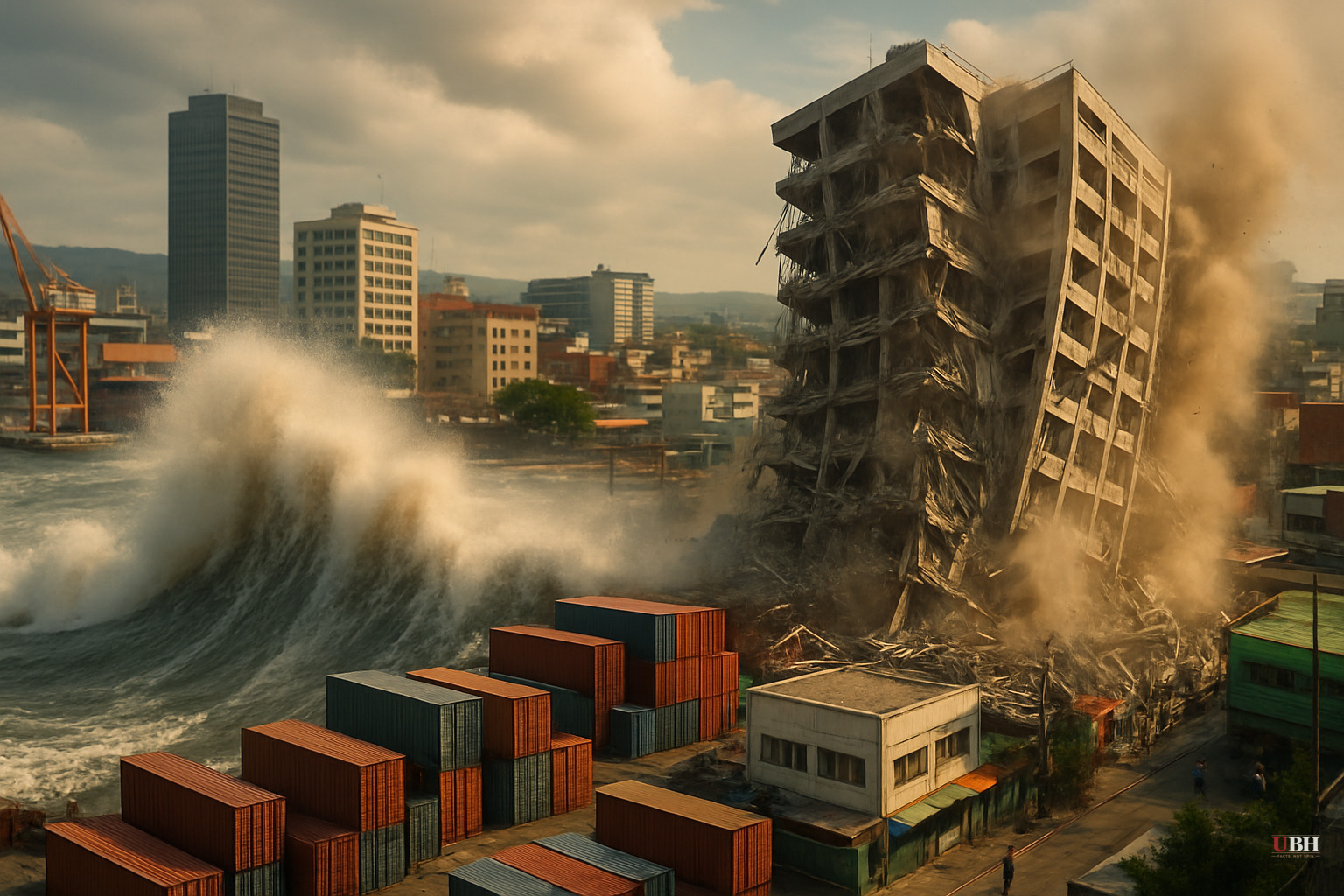
7.8 Magnitude Earthquake Strikes Southern Philippines, Triggering Tsunami Waves and Building Collapses in General Santos
What Happened
At 7:37 a.m. local time on Monday, June 8, a magnitude 7.8 earthquake struck off the southern coast of the Philippines, centered roughly 13 kilometers southwest of General Santos City in Mindanao — a commercial hub and major tuna-processing center of more than 700,000 people.
The U.S. Geological Survey confirmed the 7.8 magnitude. The German Research Centre for Geosciences (GFZ) initially put it at 8.2 before revising downward. Indonesia's BMKG clocked it at 7.7. The Philippine Institute of Volcanology and Seismology (Phivolcs) opened with a preliminary 7.0 before updating. All agencies confirmed this was a serious, major-scale event.
The quake struck at a depth of just 10 kilometers — shallow enough to maximize surface damage and tsunami potential.
Tsunami Waves Confirmed
Waves actually hit.
According to NPR, Phivolcs director Teresito Bacolcol confirmed 1-meter (3-foot) tsunami waves were monitored by land-based stations in the provinces of Sultan Kudarat and Sarangani. Smaller waves were detected in at least one additional province.
The Pacific Tsunami Warning Center warned that waves up to 3 meters (10 feet) were possible on some Philippine coasts. Indonesia and Malaysia also received tsunami alerts for their nearby coastlines.
Philippine President Ferdinand Marcos Jr. issued a direct public order: "Please heed the tsunami warning. Move to higher ground now. Do not wait. Your life is more important than anything left behind." According to NPR, that statement went out as evacuations were underway.
Buildings Down, Power Out
General Santos City took visible hits. Video footage — circulated widely and referenced by ZeroHedge — shows at least one commercial building collapsing, damage to a school structure, and the Jollibee fast-food building going down in real time.
DZRH radio station in Manila reported to the AP that the four-story office building housing its provincial branch partly collapsed. Staffers made it to the ground floor without injuries. It was unclear if others were trapped in the rubble, as the quake hit before standard office hours.
CNBC reported that Benjie Ancheta, police chief of Alabel town in Sarangani Province, said the police building cracked immediately after the quake — which struck during their flag-raising ceremony. Some people fainted. "This is the strongest earthquake we've experienced," Ancheta told Reuters.
Power went down across parts of the region.
Casualties: Unknown, Not Zero
As of reporting, there were no confirmed mass casualty numbers. Injuries appear likely but unconfirmed.
NPR noted explicitly that it was "not clear if people were trapped or injured" in the building collapse in General Santos. Debris fell from multiple structures onto tricycle taxis parked below. The quake struck before most offices opened, which likely limited the number of people inside collapsed buildings.
The full picture of injuries and deaths will take hours, possibly days, to emerge.
What the Coverage Is Getting Wrong
The magnitude disagreements between agencies got buried in most reports. GFZ said 8.2, then revised. Phivolcs opened at 7.0 — a full 0.8 lower than USGS. Indonesia's BMKG said 7.7. On the moment magnitude scale, 0.8 of a magnitude unit represents roughly a sixteenfold difference in energy released (each full unit corresponds to approximately 31.6 times more energy).
Mainstream outlets mostly glossed over this discrepancy and settled on 7.8 as consensus. The early confusion matters because emergency response protocols, evacuation orders, and international warnings all key off initial magnitude readings. A low-ball at 7.0 could slow the response.
ZeroHedge surfaced the building collapse footage and early video evidence faster than legacy outlets. AP and NPR stuck to official statements, which is professionally defensible but meant they were slower on the physical damage picture.
The Bigger Context
The Philippines sits squarely on the Pacific Ring of Fire — the seismically active belt wrapping from South America across the Pacific to Russia's Far East. The country experiences hundreds of quakes every year.
This particular event was caused by movement in the Cotabato Trench, according to Phivolcs director Bacolcol. General Santos is also an economically critical city — a major export hub for tuna and commercial goods in the southern Philippines. Infrastructure damage there has supply chain implications beyond the immediate humanitarian situation.
What Happens Next
Philippine authorities are still assessing damage. Tsunami watches remained active as of the latest updates, with officials monitoring for additional wave activity — which can continue for hours after the initial event.
Indonesia and Malaysia are on alert. No major damage has been reported in either country yet, but coastal communities were warned.
After a major quake, the first wave is not always the biggest. Stay off the beach until authorities give the all-clear.
Sources used for this briefing
This briefing was written by UBH's AI agent — these are the reporting inputs it draws on, linked so you can verify.