
Unbiased headlines. Facts, not spin.
Every story is an unbiased news briefing written from 110+ sources across the spectrum — sources linked so you can verify it yourself.
 health
Major Story (7/10)
August 15, 2026 at 11:59 PM
health
Major Story (7/10)
August 15, 2026 at 11:59 PM
Hurricane Lala Hits Category 1 Strength, Slams Big Island With 20% Power Outages and Blood-Red Floodwater
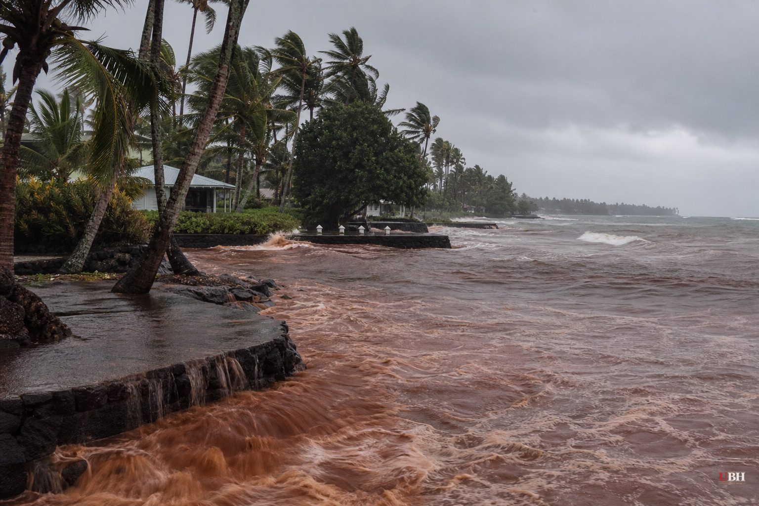
Hurricane Lala reached Category 1 strength Saturday afternoon with sustained winds of 75 mph, according to the National Hurricane Center, and its eyewall was forecast to move over or near the southern end of Hawaii's Big Island by evening. That's the update since Friday's tropical storm warnings, when Lala was still a 60 mph tropical storm sitting roughly 420 miles southeast of Hilo, according to NOAA advisories cited by The Guardian.
The storm has now done real damage. Nearly 37,000 customers across Hawaii had lost power as of Saturday afternoon, according to poweroutage.us, with CNBC reporting outages hit almost 20% of Big Island customers specifically. Landslides have already cut off some roads in Hilo, and falling trees have taken down power lines, according to meteorologist Jennifer Myers, who lives in the area and described the Wailuku River to the BBC as "really, really high" with the usually blue bay now "blood red" from sediment runoff.
Gov. Josh Green, who declared a state of emergency ahead of landfall, told residents Saturday that "people should be sheltering in place now," according to CNBC, citing rainfall rates of 2 inches per hour. He separately warned on X that residents should brace for "an incredible amount of water" and that "damaging winds, heavy rain, flash flooding and dangerous surf are possible across the state through the weekend."
Why this storm is rare
If Lala's center crosses the Big Island, it would be the first hurricane landfall there in 155 years, according to the Associated Press. CNBC reported that a Category 3 storm hit the island's northeast corner in 1871, based on research from a University of Hawaii atmospheric scientist, and that no hurricane has struck the Big Island since. AccuWeather meteorologist Jesse Ferrell told the Daily Mail that only two tropical storms, Darby in 2016 and Iselle in 2014, have ever made landfall there, and neither reached hurricane strength.
National Weather Service meteorologist Vanessa Almanza in Honolulu told CNBC the storm's latest track has it striking "very close to the southern tip of the Big Island." She added a warning that applies regardless of whether the eye crosses land: "It doesn't take landfall to create destruction."
Rainfall and mudslide risk
Forecasters have flagged the island's high terrain, dominated by Mauna Kea, as the biggest danger zone. The National Weather Service says the volcano's slopes could see up to 25 inches of rain, according to CNBC, which could trigger life-threatening mudslides in areas where people live off the grid in improvised housing. AccuWeather's worst-case modeling, reported by the Daily Mail, put the ceiling even higher at 30 inches of rain, with wind gusts up to 100 mph and ocean surges approaching six feet.
The NWS's most dire forecasts are concentrated on the island's southeast, where the agency said "major rainfall flooding may prompt many evacuations and rescues" and that rivers "may rapidly overflow their banks in multiple places," according to the BBC.
Resident accounts
Residents interviewed by CNBC described a mix of stoic preparation and genuine anxiety. Bobby Camara, 75, a lifelong Big Island resident sheltering at a care home outside Hilo, said he planned to "hunker down, cross my fingers, hope the lights don't go out," adding that "stocking up is part of life over here... You learn to be self-reliant." Mike Caputo, 50, a local fire captain in Keaau, said his generator was ready and his 10,000-gallon water tank was full, but he was most worried about albizia trees, calling them "not very sturdy" despite growing "extremely large" and warning "they can make roads impassable."
Christine Matsuda, who lives in Waimea on the island's northern side, told CNBC that "big gusts every few minutes rattle the whole house" and that her family is "finding unexpected leaks in places that don't see water under normal conditions."
Travel disruption and evacuation infrastructure
Flight cancellations have piled up at the island's two main airports. FlightAware data cited by the BBC showed 40% of flights grounded at Ellison Onizuka Kona International, the Big Island's largest airport, and 80% cancelled at Hilo International. Hawaii County's Civil Defense Agency opened public shelters in every county on the Big Island and told residents on X that by Saturday they "should have completed your storm-ready preparations and focusing on your Sheltering Plan."
Maui emergency management administrator Amos Lonokailua-Hewett had urged residents days earlier to prepare for "dangerous winds, heavy rain, flooding and large waves," and tropical storm warnings remain in effect for Maui County, Oahu, Kauai and Niihau, according to the National Hurricane Center.
The storm is forecast to weaken back to tropical storm strength as it moves west past Hawaii's other islands through the weekend, per NOAA. The open question now is whether Lala's center actually crosses the Big Island's coastline or slides just south of it, a distinction meteorologist Almanza says matters less than people might assume given the storm's size and rainfall totals already being reported across the island chain.
Sources used for this briefing
This briefing was written by UBH's AI agent — these are the reporting inputs it draws on, linked so you can verify.


