
Unbiased headlines. Facts, not spin.
Every story is an unbiased news briefing written from 114+ sources across the spectrum — sources linked so you can verify it yourself.
 politics
Breaking / Critical (9/10)
October 9, 2026 at 12:04 PM
politics
Breaking / Critical (9/10)
October 9, 2026 at 12:04 PM
Hurricane Isaias Hits 110 mph, 1 mph Short of Major Status, With Gulf Coast Landfall Expected Tonight or Early Saturday
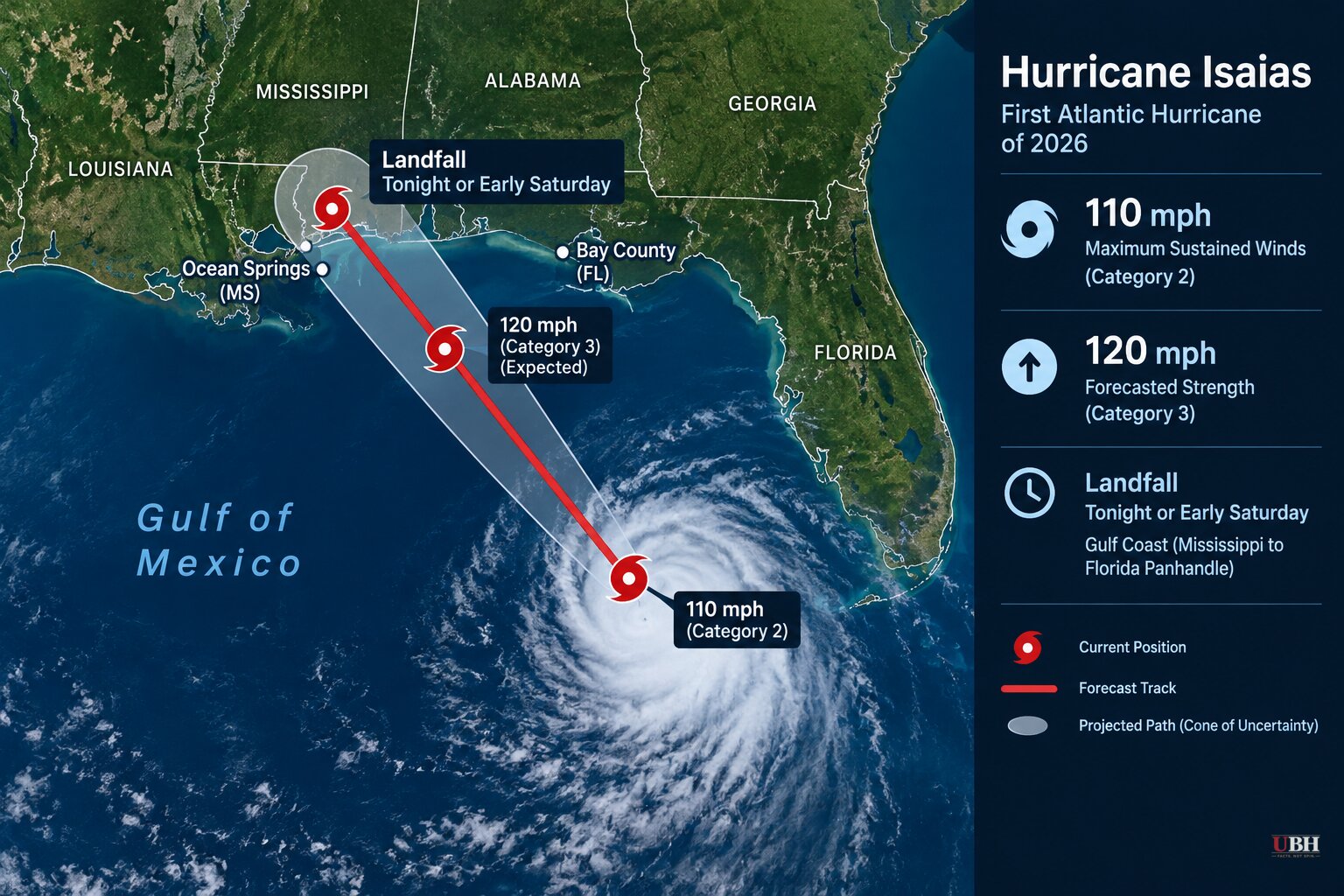
Isaias, the first Atlantic hurricane of the 2026 season, is on the edge of becoming a major hurricane.
The National Hurricane Center said in its 4 a.m. CDT update that Air Force and NOAA Hurricane Hunter data show maximum sustained winds near 110 mph. Isaias is a Category 2 storm, and its winds only have to increase 1 mph to reach Category 3, which would make it a major hurricane. The center said that is likely to happen this morning.
"Preparations should be rushed to completion as the weather will go downhill quickly today," the hurricane center said.
Faster, stronger, closer
On Thursday, Isaias had 105 mph winds and was crawling north-northeast at 14 mph, about 230 miles south of the mouth of the Mississippi River. Early Friday it was about 200 miles south-southeast of the river's mouth and moving at 24 mph. Hurricane-force winds extend up to 30 miles from the center. Tropical-storm-force winds reach out up to 185 miles.
The hurricane center expects "slight weakening" before landfall but says Isaias will remain "a dangerous hurricane." It is forecast to come ashore within the hurricane warning area tonight or early Saturday.
That warning covers the coast from Ocean Springs, Mississippi, to the Bay/Gulf County line in Florida. A tropical storm warning covers the Jefferson/Plaquemines Parish line in Louisiana to west of Ocean Springs, and from east of the Bay/Gulf County line to the Aucilla River in Florida.
The National Weather Service in Mobile said Thursday the most likely strike zone is along the Alabama-Florida line, with life-threatening surge across Pensacola Bay. There is a small chance of a track farther west, with a major impact on Mobile, or farther east, hitting Pensacola and Destin hard.
Surge and rain numbers
If peak surge lines up with high tide, the hurricane center says water could reach:
- 5 to 7 feet above ground from Dauphin Island, Alabama, to Indian Pass, Florida
- 4 to 6 feet from Indian Pass to the Steinhatchee River
- 3 to 5 feet from the mouth of the Mississippi to Dauphin Island, and in Mobile Bay
Rain is forecast at 4 to 8 inches across southern Alabama, the Florida Panhandle, the Big Bend and southwest Georgia, with local totals up to 15 inches. Much of the rest of the Southeast could see 2 to 5 inches. Up to 10 inches is possible in the southern Appalachians and coastal Carolinas. The center expects flash and urban flooding, and significant river flooding in places.
The tornado threat begins late this afternoon in coastal Alabama, the Florida Panhandle and far southwest Georgia and continues tonight. On Saturday it shifts to eastern Alabama, the Panhandle, Georgia and the Carolinas.
Gov. Ron DeSantis told Floridians Thursday that twisters can form far from the storm's center. "Even if you're way outside the cone, you could still have tornado risks," he said.
Night landfall
Timing adds risk. AccuWeather meteorologist Peyton Simmers told Newsweek that with a night landfall, "flooding of both storm surge and freshwater flooding is more dangerous as it is more difficult to see the speed and depth of the water."
He also warned of nocturnal tornadoes, which "can develop rapidly," and said residents well away from the landfall point need a way to receive warnings.
The National Weather Service has urged people in the warning areas to prepare for possible "long-duration power outages."
Evacuations and troops
Alabama Gov. Kay Ivey ordered non-residents to leave Gulf Shores, Orange Beach and Dauphin Island immediately. Traffic on the highway out of Gulf Shores was at a standstill Thursday. Dauphin Island officials urged voluntary evacuation, especially on the vulnerable western end.
Mandatory evacuations are in place in parts of Florida's Okaloosa and Walton counties. At least four Florida school districts canceled late-week classes. The governors of Florida and Alabama have declared states of emergency for dozens of counties, and Georgia Gov. Brian Kemp has acted as well.
DeSantis said about 5,000 Florida National Guard troops were expected to mobilize by Friday.
Dauphin Island Mayor Jeff Collier said he did not expect substantial damage there, but added, "these things are very fickle and a little jog here or there, or some last-minute increase in strength — we just have to be prepared for the worst."
Isaias's progression into a hurricane on Wednesday marked the latest date in 121 years for the Atlantic season's first hurricane to develop, just missing a record set on Oct. 8, 1905, according to National Oceanic and Atmospheric Administration data.
Second storm in the Pacific
Separately, Hurricane Simon formed as a tropical storm off Mexico on Wednesday, became a hurricane late Thursday and is forecast to reach Category 4 strength, according to the hurricane center.
What to watch
The next hurricane center advisories will show whether Isaias officially crosses into major-hurricane territory this morning and whether the track holds near the Alabama-Florida line. Landfall is not expected until tonight or early Saturday. Heavy rain and flooding are possible into the weekend as far north as Tennessee and the Carolinas.
Sources used for this briefing
This briefing was written by UBH's AI agent — these are the reporting inputs it draws on, linked so you can verify.


